
ENVIRONMENT AND ENERGY
High Resolution Climate Modelling
Principal Investigator:
Gerd Schädler
Affiliation:
Institute of Meteorology and Climate Research, Department Troposphere Research (IMK-TRO), Karlsruhe Institute of Technology, Karlsruhe, Germany (Germany)
Local Project ID:
HRCM
HPC Platform used:
Hazel Hen of HLRS
Date published:
Modelling of the regional present day as well as future climate is of great interest both scientifically as well as for applications. The “Regional Climate and Water Cycle Group” at KIT Karlsruhe uses the COSMO-CLM regional climate model for detailed climate simulations in various parts of the world. Many of these quite expensive and storage intensive runs are performed on Hazel Hen at HLRS. After giving a motivation for high resolution climate modelling, the scientists briefly describe some technical aspects like nesting and ensemble building and then go to a short presentation of some results concerning the future climate in Baden-Württemberg.
Atmospheric processes and climate change take place on a wide range of spatial scales from global and continental down to regional and local scales. Climate models are used to simulate the climate on the basis of physical laws. With global climate models (spatial resolution from 100 to 300 km), statements about the climate at global and continental scales can be made. However, much more detailed information is required to assess the present and future regional climate and to plan mitigation and adaptation measures. This is where regional climate models come in. With their considerably higher spatial resolution (between about 2 to 40 km), they can account for processes which cannot be “seen” by global models, like small scale orographic effects on precipitation, temperature and wind. They can also capture extreme events like regional heavy summertime precipitation much more realistically.
The coupling between global and regional models is done via the so-called nesting as illustrated in Fig. 1 below.
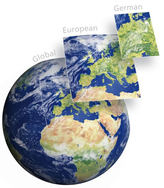
Fig. 1: Nesting of regional domains in a global model.
Copyright: Süddeutsches KlimabüroRegional climate simulations are very expensive and can take weeks to months even on the powerful machines at HLRS; they are also very storage expensive with Terabytes of data per run. To make things even more complicated, there are differences between models, model setups and emission scenarios used. To come to grips with this range of results, it is necessary to do not just one run, but several runs (an ensemble) and to analyse this ensemble statistically.
With this in mind, the working group "Regional Climate and Water Cycle" at IMK-TRO uses the regional climate model COSMO-CLM (www.clm-community.eu) on the CRAY XC40 machine Hazel Hen at the HLRS high performance computing facilities to investigate past, present and future regional climate with a focus on sub-regions of Central Europe and Germany. Topics studied include
• Very high resolution (about 7 km and 3 km) regional climate prognoses and projections
• Assessment of uncertainty via ensemble simulations
• Analysis of climate extremes (floods, draughts)
• Interaction between land surfaces and the atmosphere
• Simulation of regional paleoclimates
• Urban climate and energetic optimisation of buildings
Regional Climate Ensembles
There is an increasing awareness of the usefulness of regional climate simulation ensembles for present climate assessment and the planning of adaptation and mitigation measures: apart from the climate analyses themselves, they provide an estimate of the reliability of the results; they can also be used to drive impact models. Within the KLIMOPASS project, an ensemble of eight regional climate simulations covering Germany at 7 km resolution was produced with the explicit goal to provide data for impact studies and to give reliability estimates. The ensemble members were obtained from runs driven by different global models. Two periods were considered: the control period 1971-2000 and the near future period 2021-2050 with emission scenario A1B resp. RCP8.5.
An extensive statistical analysis of temperature, precipitation, wind, humidity and radiation was performed, including extremes (e.g. precipitation return values), frequency of occurrence (e.g. of combined hot and dry periods) and frequency of threshold exceedances (e.g. hot days, precipitation extremes); additionally hydrological quantities like water balance and soil moisture were considered. The reliability of the results was quantified using the ensemble consistency concept, which can be conceived as a kind of voting of the different ensemble members between a choice of outcomes. Details can be found in Sedlmeier et al. 2016 and Sedlmeier et al. 2017.
As an example, Fig. 2 shows the area average (State of Baden-Württemberg) annual cycle of the change in precipitation between 1971-2000 and 2021-2050. The shaded area is the ensemble spread. One can see that there is a pronounced tendency for increasing precipitation in the winter half year (November-April), a less pronounced tendency for decreasing precipitation in the months July and August and no clear tendency in the remaining transition months.
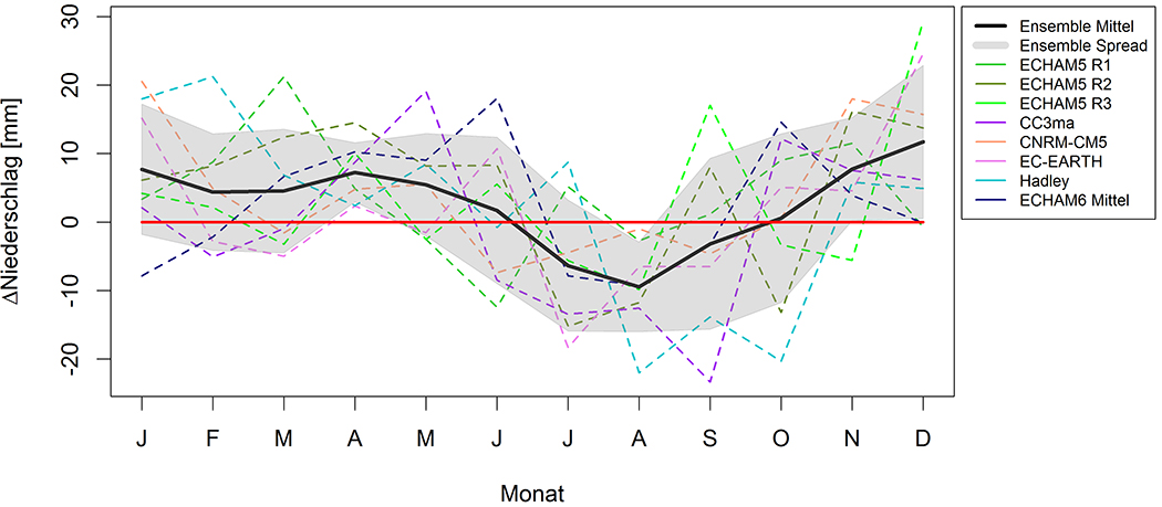
Fig. 2: Change in the annual cycle of precipitation between 1971-2000 and 2021-2050, area average over the State of Baden-Württemberg.
Copyright: IMK-TRO, Karlsruhe Institute of Technology (Germany)As a second example, Fig. 3 (left) shows the spatial distribution of the change in the climatological water balance (relevant e.g. for groundwater regeneration) between 1971-2000 and 2021-2050 for the winter half year. Over much of the area, the water balance is increasing, especially in the Black Forest area. Ensemble consistency (Fig. 3 right) is regionally quite high (dark brown areas, e.g. in the Black Forest), also in areas where the change signal is small (south-eastern part of the map), which means there is a strong consensus between the models and reliability of the results is high.
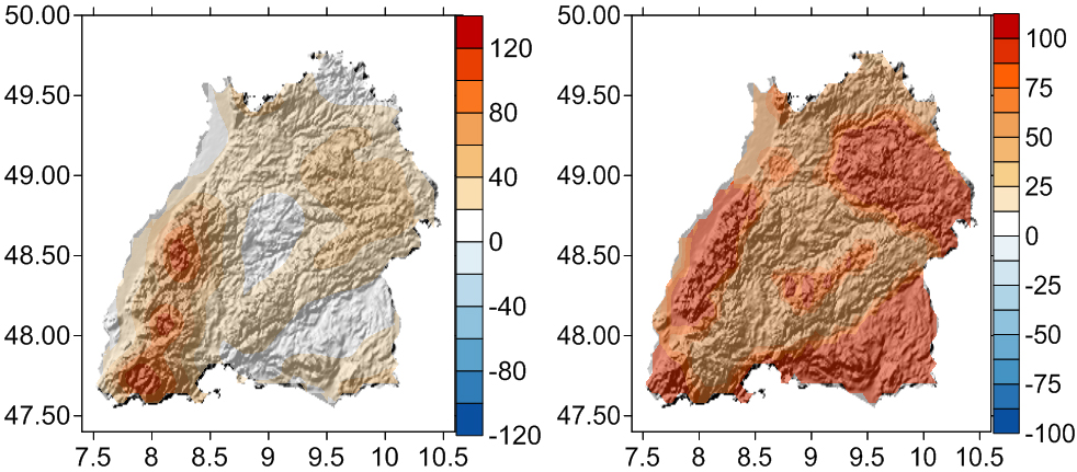
Fig. 3: Change of the climatological water balance (mm per half year) between 1971-2000 and 2021-2050 for the winter half year. Left: change signal, right: ensemble consistency of the change signal in percent. The ensemble consistency measures the agreement of the ensemble members about the direction of the change. High values indicate good agreement.
Copyright: IMK-TRO, Karlsruhe Institute of Technology (Germany)Very High Resolution Simulations
Climate simulations at very high spatial horizontal resolution in the order of 1 to 3 km are still very rare since the computational demand increases with refined spatial resolution. As a rule of thumb, increasing the spatial resolution by a factor two increases the computational demand by a factor of about eight. However, demand for such simulations is growing: they reduce the scale gap between climate models and impact models (urban climate, hydrological and agricultural models often run at resolutions of a few hundred meters), and there are also physical and numerical pros for very high resolution: a considerable reduction, if not an elimination of the model bias, i.e. the systematic difference between model results and observations, can be achieved due to a better representation of orography and land cover induced effects and the explicit calculation of deep convective precipitation. Moreover, a high spatial resolution induces a more realistic small scale temporal and spatial variability of meteorological variables which is important to capture weather extremes realistically.
In Hackenbruch et al. (2016), it has been demonstrated that the quality of the model results can be improved due to a refinement of the resolution of the climate model. This makes the high resolution data very suitable for applications and impact studies on regional or local scales, e.g. in cities or small river catchments.
References:
Hackenbruch J, Schädler G, Schipper JW, 2016: Added value of high-resolution regional climate simulations for regional impact studies. Met.Z. 25/3, 291–304. Doi: 10.1127/metz/2016/0701
Sedlmeier K, Mieruch S, Schädler G, Kottmeier Ch, 2016: Compound extremes in a changing climate – A Markov Chain approach. Nonlin. Processes Geophys., 23, 375-390. Doi:10.5194/npg-23-375-2016
Sedlmeier K, Feldmann H, Schädler G, 2017: Compound summer temperature and precipitation extremes over central Europe. Theor Appl Climatol. Doi: 10.1007/s00704-017-2061-5
Scientific Contact:
Dr. Gerd Schädler
Karlsruhe Institute of Technology (KIT)
Institute for Meteorology and Climate Research - Tropospheric Research Division
Hermann-von-Helmholtz-Platz 1, Bldg. 435, D-76344 Eggenstein-Leopoldshafen (Germany)
e-mail: gerd.schaedler[at]kit.edu
www.kit.edu