
ENVIRONMENT AND ENERGY
Irradiance Modelling for Integrated Photovoltaics with OpenStreetMap
Principal Investigator:
Dr. Evgenii Sovetkin
Affiliation:
Forschungszentrum Jülich GmbH
Local Project ID:
irrosm
HPC Platform used:
JUWELS CPU of JSC
Date published:
Abstract
Irradiation modeling is a crucial aspect of integrated photovoltaic (PV) system yield prediction and optimizations of the design and dimensions of PV systems. Shading models typically rely on high-resolution topography data that includes buildings and vegetation. However, the cost and limited availability of such data pose significant challenges. In this project, we took an innovative approach by considering an alternative source of topography data: maps. Specifically, we focused on the OpenStreetMap (OSM) due to its open-data availability. While maps cannot be directly used for irradiance modeling, we explored novel approaches to overcome this challenge.
Report
Shading losses from topography are the primary source of losses for integrated photovoltaics (PV), such as vehicle-, building- or road-integrated PV. The precise performance of such systems in the natural environment depends on the specific type of vegetation and buildings around the observer, and therefore, an accurate source of topography data is required.
Aerial-based LiDAR scans provide the most accurate data that describes the three-dimensional structure of the environment. However, due to the costs of such measurements, this sort of data is only available in a few locations around the world. In this work, we explore the possibility of using less accurate but widely available source spatial data: OpenStreetMaps.
OpenStreetMaps cannot be used directly for irradiation modeling, as it provides no altitude information. Therefore, we use the high-resolution LiDAR data to model irradiation to train a model that uses purely OpenStreetMaps. To accomplish our research objectives, we undertook a comprehensive data collection effort. We gathered a vast sample (300,000 km^2) of high-resolution topography data from multiple European countries and states in the USA. This extensive coverage allows us to examine the effects of topography, climate, and city planning styles on shading losses and light non-uniformity across various PV applications: vehicle- and building-integrated PV and PV on the road.
The HPC system was primarily used to model irradiation in selected locations and for different PV applications, such as irradiation of vehicle bodies on streets, buildings, and road surfaces. During the project, a new horizon algorithm was discovered, allowing to dramatically (four times improvement in computation speed) reduce computation requirements for irradiation modelling [1,2]. The new approach facilitated large-scale simulations for vehicle-integrated PV [3], where we quantify the non-uniformity of light and identify topography as the primary source of that. Furthermore, we performed simulations for all buildings within North-Rhine Westphalia, evaluating solar potential on roofs and building facades.
Lastly, the compute time was used to generate so-called shadow maps, which were used for training and image-to-image neural network (Figure 1). The resulting model gave an important insight into the accuracy that can be achieved with such models. Although inaccurate on individual-PV-cell level, the model can accurately evaluate solar potential averaged over relatively small areas (1000 m^2). Furthermore, the proposed OSM irradiation models work two orders of magnitude faster than the classical approach that relies on high-resolution topography data.
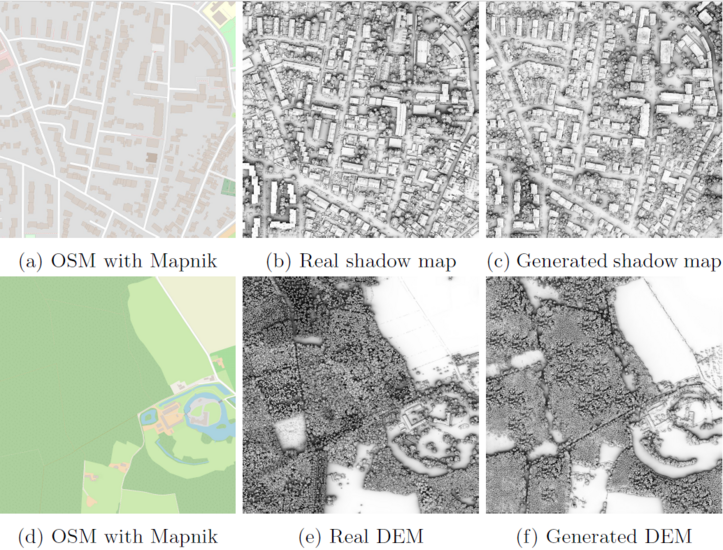
Figure: Shadow probability maps generation with Pix2PixHD. Resolution: 0.25 m2/pixel, area: 1 km2
The insights gained during the project may benefit the design of PV modules, where specific cell interconnections and the arrangement of bypass diodes will reduce the electrical losses due to light non-uniformity. Furthermore, the proposed OSM irradiation model can be used efficiently in recommender systems for vehicle routing and parking, maximizing the energy harvested by vehicles from the Sun.
References
[1] E. Sovetkin, A. Gerber, and B. E. Pieters. “Improving horizoncomputation algorithm with quasirandom sequences”. In: International Journal of Geographical Information Science (2024). DOI: 10.1080/13658816.2024.2408751
[2] E. Sovetkin, A. Gerber, and B. E. Pieters. “Fast Horizon Approximation: Impacts on Integrated Photovoltaics Irradiation Simulations”. In: Solar RRL (2024). DOI: 10.1002/solr.202400474
[3] E. Sovetkin, A. Gerber, and B. E. Pieters. “Non-uniformity of irradiation distribution on vehicles’ bodies”. In: Progress in Photovoltaics: Research and Applications (2024). under review. DOI: 10.22541/au.172114508.82017107/v1