
ENVIRONMENT AND ENERGY
Resolving Cloud-Turbulence Interactions in the Climate System
Principal Investigator:
Prof. Dr. Juan Pedro Mellado
Affiliation:
Universität Hamburg, Meteorologisches Institut, Hamburg, Germany
Local Project ID:
pn49de
HPC Platform used:
SuperMUC-NG PH1-CPU at LRZ
Date published:
Introduction
Stratocumuli are low level clouds at the top of the atmospheric boundary layer, at altitudes of about 1 km and with thicknesses of about 100 m. They are key elements of the climate system. On the one hand, they extend over thousands of kilometers in the eastern boundaries of the subtropical oceans, e.g., off the coasts of California, Peru, and Namibia, favored by the temperature contrast between the cold upwelling water and the warm subsiding air. On the other hand, they reflect more incoming solar radiation (higher albedo) than the underlying surface of the ocean, while they emit similarly in the long-wave range. This combination of large coverage and net cooling effect substantially affects the Earth’s radiative budget. How will stratocumuli change with climate warming? Despite continuous efforts, we still do not know [1].
A major difficulty is to understand how stratocumuli break and how this depends on the environmental conditions. Stratocumuli are embedded in the marine boundary layer and therefore depend on the sea surface temperature and the free tropospheric conditions. At the same time, the cloud-top region plays a crucial role. It is here where turbulent convection starts, which helps to maintain the cloud, but also where the cloud mixes with the warm air above it, contributing to cloud break-up. The cloud-top region is very thin and experiences rapid changes; for instance, the temperature can vary 10 K within only 10 m. This implies that simulating cloud-turbulence interaction needs meter-scale resolution or less [2]. Simulation techniques such as direct numerical simulation (DNS) now reach this resolution [3].
This LRZ project focuses on the cloud-top region and on one cloud-turbulence interaction: droplet sedimentation. Because of the gravitational force, cloud droplets tend to fall. Their typical fall speed in stratocumuli is on the order of millimeters per second, much smaller than the turbulent velocity fluctuations and comparable to the rate at which the cloud top, in the mean, moves up and down. Our previous work suggested that insufficient resolution and numerical artifacts mask the effect of sedimentation in stratocumuli, which challenges the current consensus on the role of these clouds in the climate system [4,5]. This work, however, neglected the finite size of the cloud and the vertical transport across the boundary layer, which connects the sea surface with the cloud-top region. In this project, we have addressed this gap and considered the whole boundary layer, as shown in Figure 1.
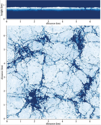
Figure 1: Vertical cross-section (top) and horizontal cross-section through the cloud (bottom) of the liquid water content: white, cloud; blue, dry air.
Results and Methods
There are 3 major findings so far. First, we have found that the effect of sedimentation is of order one, as shown in Figure 2, which confirms the hypothesis that we need 1 m resolution or less to resolve cloud-turbulence interaction in stratocumuli. The second main result is that, in contrast to previous studies, the turbulent entrainment intensifies, although the mean entrainment velocity diminishes. The reduction in mean entrainment velocity is caused by the sedimentation flux, which opposes the turbulent flux. This is important for parametrizations in global climate models. Last but not least, simulations show a tendency towards Reynolds number similarity in cloud-relevant properties such as the integrated water content, shown in Figure 2. This allows us to extrapolate simulation results to atmospheric conditions more reliably.
To obtain these results, we have performed DNS of the marine boundary layer in domains of 6 km and with environmental conditions corresponding to the DYCOMS-II field campaign. We varied two parameters, namely, the sedimentation strength and the Reynolds number. The Reynolds number is equivalent to the grid spacing, and we have achieved resolutions of 1 m. The grid size in this last case spans 6,144 points in each horizontal direction and 1,536 points vertically, making these simulations the largest worldwide for studying this specific problem. The computational time used in all these simulations is 45 million core hours in SuperMUC-NG, 30 million corresponding to the high-Reynolds number simulation.
We rely on DNS because it solves the Navier-Stokes equations directly, without turbulence models, which removes the uncertainty associated with these models. For this problem, we use the anelastic approximation to the Navier-Stokes equations to remove the acoustic waves, which is a good approximation because of the small air velocities [4]. Grid sensitivity studies allow us to obtain grid independent results. Reynolds-number sensitivity studies (considering 4 m, 2 m and 1 m grid spacing, see Figure 2) allow us to estimate the role of limited scale separation in the simulations compared to atmospheric conditions.
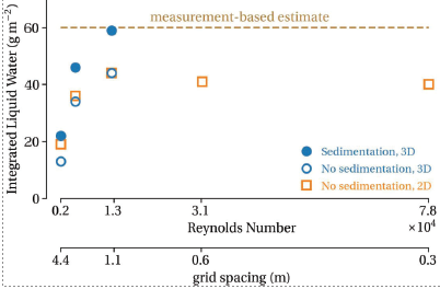
Figure 2: Dependence of the water content on sedimentation strength and Reynolds number (grid spacing). Measurement-based estimate corresponds to the DYCOMS-II field campaign. 2D simulations were used to explore Reynolds number similarity.
The numerical algorithm is based on sixth-order compact finite differences to discretize the spatial derivatives, and low-storage, fifth-order Runge-Kutta schemes for the temporal integration. The pressure-Poisson equation is solved by a Fourier decomposition in the two horizontal directions. The code is written in Fortran 2008 and uses MPI for the domain decomposition in the two horizontal directions. The code is publicly available [6].
Ongoing Research/Outlook
The capability for such high-resolution studies relies exclusively on supercomputers like SuperMUC-NG, encompassing both computational and data aspects. Each 3D field occupies 216 GiB of disk space, and, to describe the system, we need 5 fields along with their temporal evolution. The post-processing also needs an easy access to this large amount of data to calculate averages, spectra or visualizations.
The current challenge is to accelerate the code. As illustrated in Figure 2, we want to increase the Reynolds number to confirm the tendency towards Reynolds-number similarity, which would allow us to extrapolate results from simulations to atmospheric conditions more reliably. Ideally, this means reducing the grid spacing by a factor 2, which implies an increase in computational resources by one order of magnitude.
Accelerating the code will also allow us to study the effect of different environmental conditions and thereby how stratocumuli will change in future climates, as the sea surface temperature and the free troposphere in the subtropics change. Part of this work is already ongoing as a continuation of this project, in particular, testing the hypothesis that insufficient resolution in the cloud-top region has masked cloud-adjustment mechanisms associated with entrainment and sedimentation.
To accelerate the code, we have considered serial and parallel optimization. Our reformulation of the pressure-Poisson solver reduces the number of linear systems to solve and increases stability with non-uniform grids. We have also reformulated the I/O to single precision to save disk space. Currently, we are considering the MPI communication in single precision as well. We also want to reformulate the calculation of the evolution equations to increase locality in memory.
References and Links
[1] L. Nuijens, P. Siebesma, Curr Clim Change Rep, 5 (2019) 80-94.
[2] J.P. Mellado, Annu Rev Fluid Mech, 41 (2017) 145-169.
[3] J.P. Mellado et al., J Adv Model Earth Syst 10 (2018) 1421-1438.
[4] A. Lozar, J.P. Mellado, J Atmos Sci 74 (2017) 751-765.
[5] B. Schulz, J.P. Mellado, J Adv Model Earth Syst 11 (2019) 1830-1846.