
ENVIRONMENT AND ENERGY
ViWA (VirtualWaterValues) - Multi-Scale Monitoring of Global Water Resources and Options for their Efficient and Sustainable Use
Principal Investigator:
Prof. Dr. Wolfram Mauser
Affiliation:
Ludwig Maximilians Universität, Munich, Germany
Local Project ID:
pn69pe
HPC Platform used:
SuperMUC-NG at LRZ
Date published:
Abstract
More food for a growing human demand needs more water to produce it. Nevertheless, global water resources are limited. Without appropriate action towards a most efficient and most sustainable water use, the world will run into a severe water crisis.
In the BMBF research project ViWA we show how High Performance Computing using SuperMUC-NG can open new ways to create the necessary knowledge for action towards more efficient and sustainable water use in agriculture. Complex global crop growth simulations based on climate and environmental data show how water could globally be saved through better farm management. Comparing simulations with actual global crop growth observations using Sentinel-2 satellites create a global monitoring system, which points at hot-spots of water waste, where action to improve farm management is needed.
Introduction
We are facing a world with growing population and yet limited water resources. The demand for water to grow crops makes agriculture the world’s largest water consumer. We need to use the available water as efficiently and sustainably as possible to ensure that both food security is maintained (and even strengthened) and nature and its biodiversity is preserved globally. This is strongly stated in the Sustainability Development Goals (SDGs) of the United Nations (UN). Nevertheless, agriculture currently wastes a large portion of water through inefficient and unsustainable practices. Detailed, local and repeated information on the actual amount of crop yield we get per m³ of evaporated water (the agricultural water use efficiency AWUE (kg/m³)) is the prerequisite to reduce water waste in agriculture. Since AWUE cannot be measured directly, detailed, local AWUE information is yet unavailable globally.
Results and Methods
The BMBF ViWA (Virtual Water Values) project aims to close this knowledge gap by using an innovative approach of combining global environmental simulations and remote sensing observations: a process-based, dynamic environmental model globally and with high spatial and temporal resolution simulates crop growth, yield and water use for the major food and feed crops and a whole variety of different environmental conditions and farming practices. A unique global dataset is produced, which demonstrates through simulated management scenarios all achievable AWUEs and yields for all farming locations on the Globe. The huge Earth observation data streams of the COPERNICUS Sentinel-2 satellites, after adequate processing, deliver global and up-to-date data on crop growth from all corners of the Globe. By comparison with scenario simulations these satellite based measurements of crop growth allow choosing from all possible simulated management scenarios and crops the one realized at each location on the Globe. The result is a global system that can monitor AWUE and its change over time, thereby allowing to identify regional and local hot-spots of improving and deteriorating AWUE.
The dynamic global crop growth simulations are numerically demanding. Thanks to the computational power of the HPC system SuperMUC-NG and by using approx. 5 Mio. CPU hours of computation time, the generated dataset has the unprecedented high spatial (30 arcsec, i.e. about 1 km at the equator) and temporal resolution (1 hour), which is needed to establish a useful monitoring system. ViWA uses the simulation model PROMET (Mauser & Bach 2009). PROMET is developed in FORTRAN and completely parallelized using OpenMP. Complex coupled physical and biological processes are simulated on ca. 54 billion pixels driven by downscaled global climate data. For each pixel, timestep and crop both energy balance (temperature, radiation, latent heat flow etc.) and mass balance (carbon and water uptake and release) are closed by numerically iterating the coupled equations describing the processes of the land-surface interaction, plant photosynthesis and phenological development in a dynamic crop growth model.
The results of the simulations consist of about 100 TB of (compressed) raster data. The complete set of data contains
- information on a total of 17 modelled agricultural parameters like yield, AWUE, evapotranspiration, irrigation water and growing degree days
- for 16 crops: maize, wheat, soybean, rice and others
- in 8 different farming scenarios ranging from low intensity (low nutrient rate and no irrigation) to high intensity (high nutrient rate and irrigation where needed)
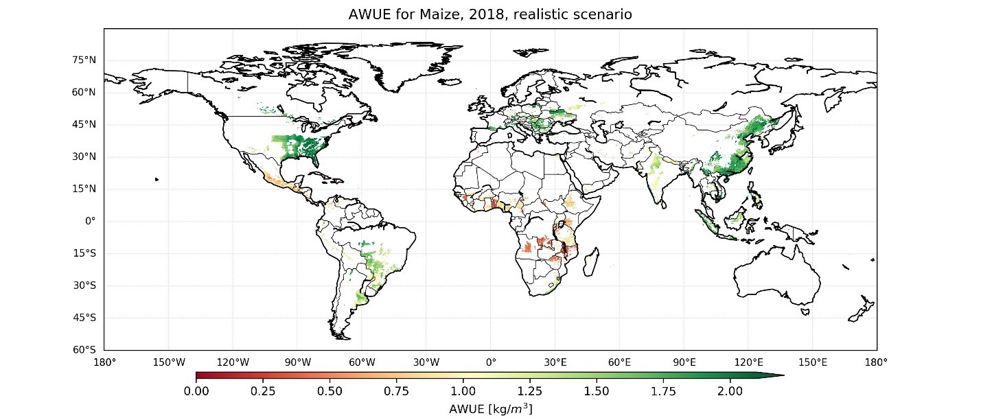
Figure 1: Agricultural water use efficiency (AWUE) for Maize in 2018, determined with ViWA’s global monitoring system of agricultural management.
The detailed analysis of the generated data is yet ongoing. However, to show the new and large potentials of the dataset, the first global map of AWUE of Maize in 2018, derived from a lower resolved test simulation run, is presented in figure 1. This global map allows the identification of hot- and clod-spots with low (or high) agricultural water use efficiency: while AWUE is high (i.e. up to 2 kg/m3) in most parts of Northern America, Europe and Western Asia, the AWUE values for Africa and Central America are low to very low. In order to promote sustainable und efficient water use in agriculture, especially these low AWUE hot spots need to be considered and addressed.
Scientists, policy-makers and farmers alike may profit from knowledge gained in the ViWA project. Therefore, the modelled results as well as the adjoint insights will be made publicly available through the LRZ’s Data Science Storage (DSS) and the Food-Security - Thematic Exploitation Platform (FS-TEP) of the European Space Agency.
Further information and references
MAUSER, W. & BACH, H. (2009): "PROMET - Large scale distributed hydrological modelling to study the impact of climate change on the water flows of mountain watersheds," Journal of Hydrology, vol. 376, pp. 362-377.Viwa homepage
ViWA project homepage: viwa.geographie-muenchen.de