ENVIRONMENT AND ENERGY
WRF Simulations to Investigate Processes Across Scales (WRFSCALE)
Principal Investigator:
Hans-Stefan Bauer
Affiliation:
Institute of Physics and Meteorology, University of Hohenheim
Local Project ID:
WRFSCALE
HPC Platform used:
Hazel Hen of HLRS
Date published:
Numerical models are excellent tools to improve our understanding of atmospheric processes across scales, since they provide a full 4D representation of the atmosphere and produce a consistent state with respect to the 3D thermodynamic atmospheric fields, cloud water, cloud ice, and diagnostic variables such as precipitation. Further improvements are expected if a chain of grid refinements is performed down to the Large-Eddy Simulation (LES) scale (100 m and below), as further details of land-surface atmosphere (LSA) interaction are resolved. WRFSCALE bundles several sub-projects working in this field.
Nested turbulence-permitting simulations with the Weather Research and Forecast model (WRF) have been conducted. Operating such high resolutions with an NWP model has the advantage of explicitly simulating the turbulent exchange processes between the land surface and the atmosphere of the moisture, heat and momentum in the planetary boundary layer (PBL) under realistic conditions. Therefore, the impact of a specific weather situation on the development and the transport happening inside the PBL can be investigated.
Within this subproject, simulations of selected case studies during the Land Atmosphere Feedback Experiment (LAFE) (Wulfmeyer et al., 2018) will be carried out to perform detailed comparisons with observations to improve the process understanding and their representation in the model. A first simulation down to a resolution of 100 m was carried out for the 23rd of August 2017. It was a clear sky day where the operation of the lidar systems was temporally extended to include the evening transition of the convective boundary layer.
The simulation was started at 06 UTC (01 local time) and ran for more than 22 hours within the 24 hours wall time limit and was our first simulation containing both the morning and the evening transitions between the nighttime stable and the daytime convective boundary layer.
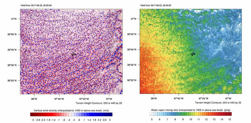
Figure 1 illustrates the fully developed convective boundary layer 1000 m above sea level in the afternoon (local time) of August 23 in the 100 m domain.
The vertical velocity field 1000 m above sea level illustrates a typical convective boundary layer undisturbed by clouds. The circulation broke apart into turbulent eddies of different size. Small regions of intense updrafts (blue) are surrounded by larger regions of weaker compensating downdrafts (red). The sizes of the developing structures correspond to observations. Furthermore, regions over flat terrain where the turbulence develops isotropically can be separated from regions where coherent structures develop influenced by the underlying orography.
Another aspect within WRFSCALE is the topic of geoengineering. Previous studies have demonstrated that large-scale land surface modifications can affect the weather, potentially in a controllable and predictable way (Becker et al, 2013; Branch et al., 2014, Branch and Wulfmeyer, 2019). However, these studies have all been based on very large scales – 100 × 100 km. The goal is to assess the impact of smaller and more feasible land surface modification scenarios. This was done via single day simulations with the WRF-NOAHMP model under varying atmospheric conditions.
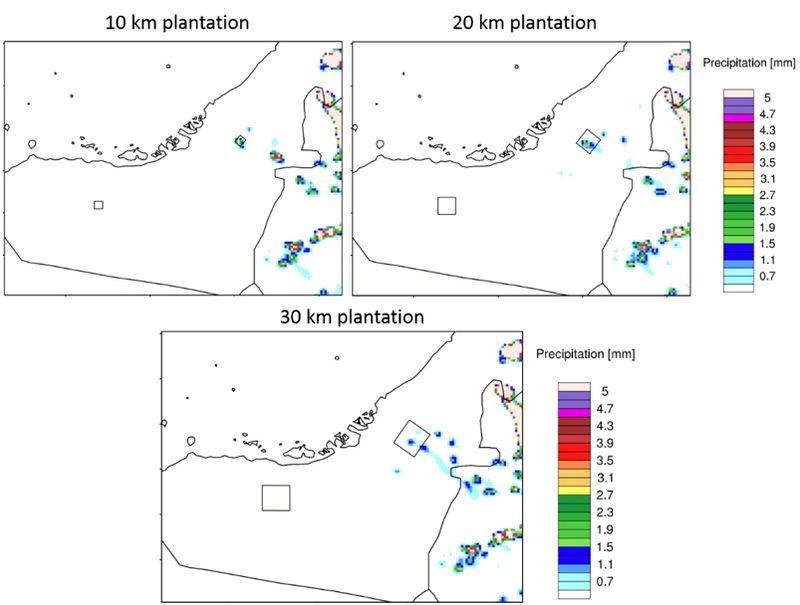
Figure 2 shows the impact on rainfall over the whole day for different sizes of the plantations (boxes). It is clear that all sizes have a large impact on rainfall, whereas almost no precipitation occurred in the control simulation without plantations, not shown, there is little rainfall around the plantation areas. However, there is a difference in impact from the scale of the plantations both spatially and in the amounts.

Figure 2: Accumulated rainfall on 27.07.2015 for all three scenarios [mm] ending at 00:00 UTC. © University of Hohenheim
These simulations indicate that conditions in summer in the UAE are conducive for impacts from small plantations down to 10 km size.
Another topic is the enhanced understanding of cloud development over the Arabian Peninsula which is an important aspect with respect to cloud seeding applications. Due to the special topography over the United Arab Emirates (UAE), a turbulence permitting simulation for July 14, 2015 has been carried out. Here, we applied a nested approach for a target horizontal resolution of 300 m. This type of simulation requires around 7,200 cores in Hybrid mode and 4:45 hours wall-clock time for 24 hours of simulation (including I/O every minute). The output of such a simulation varies around 4 TB.

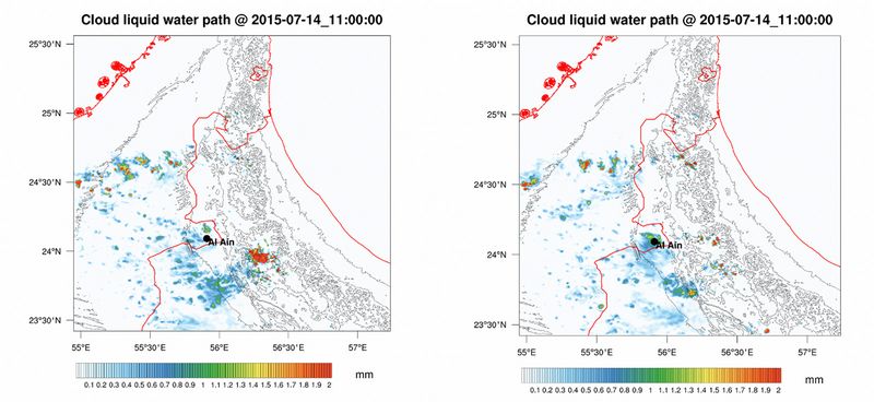
Figure 3: Cloud water path (mm) of the turbulence-permitting domain with PBL (left) and without a PBL parametrization. © University of Hohenheim
As an example, Fig. 3 shows the simulated cloud liquid water path with and without the application of a PBL scheme. Both simulations show similar cloud patterns, although it appears that the simulation with a PBL parameterization simulates weaker convection, which is partly reflected in the rainfall patterns (not shown here). The maximum rainfall amount is approx. 13 mm without PBL scheme and 24 mm when a PBL scheme is applied. Apparently, the PBL scheme enhances the development of convection in this particular case.
In addition to the turbulence permitting simulation, we decided to set up a five-member physics ensemble with different combinations of PBL and cloud microphysics in order to achieve a sufficient spread among the simulations at the convection permitting resolution of 2.7 km. Our results demonstrate a most realistic representation of the cloud development and cloud pattern by the combination of the Mellor‐Yamada‐Nakanishi‐Niino (MYNN) PBL and Thompson Aerosol-aware cloud microphysics, when compared to the satellite derived radiation products as well as cloud liquid water (LWP) path obtained from the Climate Monitoring Satellite Application Facility (CMSAF) based on the SEVIRI imaginary from MSG-2. Further details about this study can be found in Schwitalla et al., 2020).
Another subproject considers the importance of water vapor. Water vapor plays a crucial role in the atmosphere although its fraction is comparatively less among the other constituents. Humidity content in the atmosphere has its effect on the overall dynamics, radiation and significantly influence the development of clouds and precipitation.
Assimilation of the high-quality data obtained from lidar instruments provides a better initial state and therefore improves the quality of the forecast. Instantaneous measurements like radiosondes cannot capture the changes in the atmosphere that can be registered by continuous measurements by the lidars. In this subproject, a forward operator for the direct assimilation of water vapor mixing ratio profiles with the three-dimensional variational (3DVAR) and ensemble data assimilation methods resulted in a positive impact. The shown example used data from one intensive observation period (IOP) of the HOPE campaign which was held in western Germany during the month of April and May 2013. A 10-hour dataset was assimilated into the model with hourly data inputs. A rapid update cycle 3DVAR data assimilation was performed at hourly intervals for the entire European domain at a spatial resolution of 2.5 km and a vertical resolution of 100 levels up to 50 hPa.

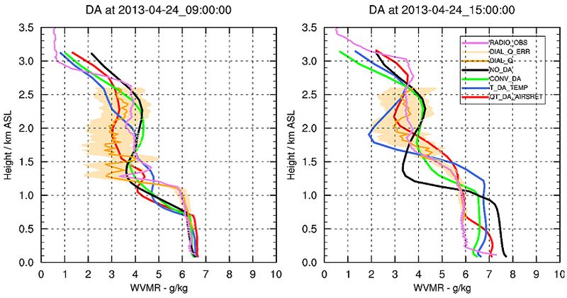
Figure 4: Left panel: Water vapor mixing ratio profile during the first assimilation. Right panel: Water vapor mixing ratio profile at 15 UTC after 6 assimilation cycles. © University of Hohenehim
The assimilation of the water vapor mixing ratio profiles corrects the model at hourly intervals where the DIAL data is fed into the model. The profile plot in Figure 4 shows the impact of assimilation on the vertical profile at the first assimilation and after six assimilation cycles. The 15 UTC assimilation shows good agreement with the DIAL profile although the model couldn’t capture the boundary layer gradient in the first assimilation at 9 UTC.
References:
Bauer, H.-S., S. K. Muppa, V. Wulfmeyer, A. Behrendt, K. Warrach-Sagi and F. Späth, 2020: Multi-nested WRF simulations for studying boundary layer processes on the turbulence-permitting scale in a realistic mesoscale environment. Tellus A accepted.
Branch, O., K. Warrach-Sagi, V. Wulfmeyer, and S. Cohen, 2014: Simulation of semi-arid biomass plantations and irrigation using the WRF-NOAH model – a comparison with observations from Israel. Hydrol. Earth Syst. Sci. 18, 1761–1783, DOI:10.5194/hess-18-1761-2014.
Branch, O., and V. Wulfmeyer: Deliberate enhancement of rainfall using desert plantations. Proceedings of the National Academy of Sciences Sep 2019, 116 (38) 18841-18847; DOI: 10.1073/pnas.1904754116
Becker, K., V. Wulfmeyer, T. Berger, J. Gebel, and W. Münch, 2013: Carbon farming in hot, dry coastal areas: An option for climate change mitigation. Earth System Dyn. 4, 237-251, DOI:10.5194/esd-4-237-2013.
Schwitalla, T, Branch, O, Wulfmeyer, V. Sensitivity study of the planetary boundary layer and microphysical schemes to the initialization of convection over the Arabian Peninsula. QJR Meteorol Soc. 2020; 146: 846– 869. doi.org/10.1002/qj.3711
Wulfmeyer, V., D.D. Turner, B. Baker, R. Banta, A. Behrendt, T. Bonin, W.A. Brewer, M. Buban, A. Choukulkar, E. Dumas, R.M. Hardesty, T. Heus, J. Ingwersen, D. Lange, T. R. Lee, S. Metzendorf, S.K. Muppa, T. Meyers, R. Newsom, M. Osman, S. Raasch, et al., 2018: A New Research Approach for Observing and Characterizing Land-Atmosphere Feedback, Bull. Amer. Meteor. Soc., 99, 8, 1639 - 1667.
Research Team
Oliver Branch, Hans-Stefan Bauer (PI), Thomas Schwitalla, Rohith Thundathil, and Volker Wulfmeyer of University of Hohenheim, Institute of Physics and Meteorology
Scientific Contact
Dr. Hans-Stefan Bauer
Institute of Physics and Meteorology
University of Hohenheim
Schloss Hohenheim 1, D-70599 Stuttgart (Germany)
e-mail: hans-stefan.bauer [@] uni-hohenheim.de
HLRS project ID: WRFSCALE
June 2020
