ENVIRONMENT AND ENERGY
Improved Characterization of Fluxes Across Compartmental Interfaces
Principal Investigator:
Clemens Simmer
Affiliation:
Meteorological Institute, University of Bonn (Germany)
Local Project ID:
hbn29
HPC Platform used:
JUQUEEN/JURECA (JSC)
Date published:
Data Assimilation is an integral tool to enable precise forecasts and becomes increasingly important to derive the values of uncertain parameters due to lack of observations. Numerical models of Earth system compartments are coupled in order to simulate physically consistent water and energy fluxes in the subsurface-landsurface-atmosphere system. Such model systems become increasingly important to analyze and understand the complex processes at boundaries of terrestrial compartments and interdependencies of states across these boundaries. As such, data assimilation for these coupled systems needs to be developed.
Numerical models of Earth system compartments are coupled in order to simulate physically consistent water and energy fluxes in the subsurface-landsurface-atmosphere system. Such model systems become increasingly important to analyze and understand the complex processes at boundaries of terrestrial compartments and interdependencies of states across these boundaries. They produce complete state evolutions which, when run at highest computationally possible resolutions while incorporating as many processes as attainable, may be regarded as a proxy of the real world.
Thus, hypotheses regarding the behavior of the coupled terrestrial system can be tested. The coupled model system is coupled to a data assimilation (DA) system which should result in state evolutions of the model system close to given observations, and also non-observed or not accessible state variables and system parameters can be estimated and predictions of future states can be made.
Researchers at the University of Bonn use the Terrestrial Systems Modeling Platform[1], which couples the atmospheric model COSMO (Consortium for Small-scale Modeling) the Community Land Model (CLM), and the groundwater model ParFlow via an external OASIS coupler. DA is performed by the Parallel Data Assimilation Framework PDAF [2], which unlike most other systems operates mainly in the computer memory and minimizes I/O-operations.

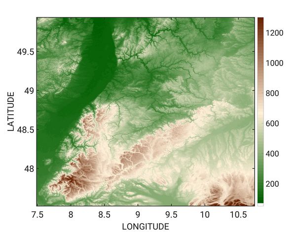
Figure 1: Topographic map of the computational region in a 400m resolution. The Neckar catchment is located in the center bordered by the Black Forrest on the SW and the Swabian Alb in the southeast. The Neckar flows into the Rhine in the Rhine valley on the western side of the domain. © Meteorological Institute, University of Bonn
The scientists' developments follow two branches. One branch is the virtual catchment, which simulates the coupled atmosphere-land surface-subsurface system at the large catchment scale at a spatial resolution as high as possible, in order to approximate as much as possible reality. The virtual catchment mimics the Neckar catchment in SW-Germany (see Figure 1 for a topographic map of the simulated region).
The Neckar catchment is a typical medium sized mid-latitude catchment, which features areas of various land-use, topography and degree of human management. For the atmosphere a resolution of 1.1km is used and currently a resolution of 400m is used for the land-surface and subsurface, but the researchers aim to increase this to 100m resolution in the nearby future. Virtual measurements are taken from this virtual catchment by observation operators and place and time of these measurements, as well as precision, can be determined by the modeler.
Since the focus is put on the regional water cycle, the system is restricted to a river catchment and selected an area, which roughly includes the Neckar in SW-Germany. Extended state evolutions are required to sufficiently sample the potential state space of the system and observation; the scientists simulate the state evolution of the virtual Neckar catchment for the time period 2007 to 2015. Figure 2 shows a snapshot of the virtual catchment with clouds, rain and volumetric soil moisture content of the upper ten soil layers (3m).
The second branch is the construction of an ensemble-based DA system, which needs many potential state evolutions simulated in parallel by the model system. Given the large number of model runs that are performed in parallel, the different model runs have to be carried out at a lower spatial resolution than the virtual reality. This work is still ongoing and results will be shared as they become available.
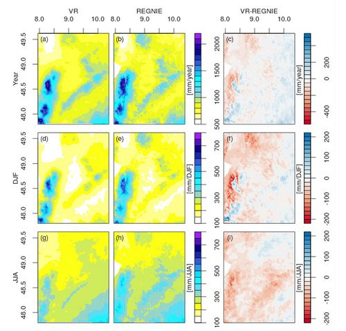
Before the virtual observations for DA can be used, the researchers have to make sure that, when compared to real measurements, the system produces statistically comparable results. Exact matches are not expected as the virtual catchment is not expected to reproduce the same random fluctuations as the Neckar catchment, and because some model assumptions are not fully congruent with the real world, especially concerning the treatment of rivers. Figure 3 shows some results from the virtual catchment concerning precipitation and Figure 4 shows the groundwater depth. The precipitation results confirm that this system works as good as any atmospheric model in simulating precipitation. Groundwater depth is in accordance with expectations with deep groundwater levels in the mountains (not in the valleys though) and shallow groundwater in the larger flatlands like the Rhine valley. Given these results, the scientists are confident to test their DA system with observations from the virtual catchment.
After successful tests, the derived methodology will be transferred and applied to real-world data from the Ruhr catchment, which is a focus area of the DFG-funded SFB TR32[3].
References
[1] P. Shrestha, M. Sulis, M. Masbou, S. Kollet, and C. Simmer A scale-consistent terrestrial systems modeling platform based on COSMO, CLM, and ParFlow, Monthly Weather Review 142(9), 3466-3483, 2014 doi:10.1175/MWR-D-14-00029.1
[2] W. Kurtz, G. He, S.J. Kollet, R.M. Maxwell, H. Vereecken, and H—J. H. Franssen TerrSysMP-PDAF version 1.0): a modular high-performance data assimilation framework for an integrated land surface-subsurface model, Geoscientific Model Development 9(4), 1341-1360, 2016 doi:10.5194/gmd-9-1341-2016
[3] C. Simmer, I. Thiele-Eich, M. Masbou, W. Amelung, S. Crewell, B. Diekkrueger,F. Ewert, H. J. Hendricks Franssen, A. J. Huisman, A. Kemna, N. Klitzsch, S. Kollet,M. Langensiepen, U. Loehnert, M. Rahman, U. Rascher, K. Schneider, J. Schween,Y. Shao, P. Shrestha, M. Stiebler, M. Sulis, J. Vanderborght, H. Vereecken, J. vander Kruk, T. Zerenner, and G. Waldhoff Monitoring and Modeling the Terrestrial Sys-tem from Pores to Catchments - the Transregional Collaborative Research Center onPatterns in the Soil-Vegetation-Atmosphere System Bulletin of the American Meteo-rological Society 96, 17651787, 2015 doi:10.1175/BAMS-D-13-00134.1
[4] https://www.dwd.de/DE/leistungen/regnie/regnie.html
Scientific Contact:
Prof. Dr. Clemens Simmer
Meteorological Institute (MIUB)
Rheinische Friedrich-Wilhelms Universität Bonn
Auf dem Hügel 20, D-53121 Bonn (Germany)
e-mail: csimmer[at]uni-bonn.de
January 2018
JSC project ID: hbn29


